Walking & Bicycling
Bike To School Day, Beacon, New York
A lack of safe walking infrastructure was the most common daily transportation challenge in our public survey, cited by nearly half of respondents. A lack of safe bicycling routes was cited by almost 30 percent of respondents. When asked about transportation priorities for their community, almost 40 percent selected ‘better walking routes and access’, while almost 30 percent chose ‘better bicycling routes and access.’
Clearly, walking and bicycling infrastructure is important to county residents, and we must continue to work with State, County and local partners to improve access via walking and bicycling.
Walking
How walkable are our centers?
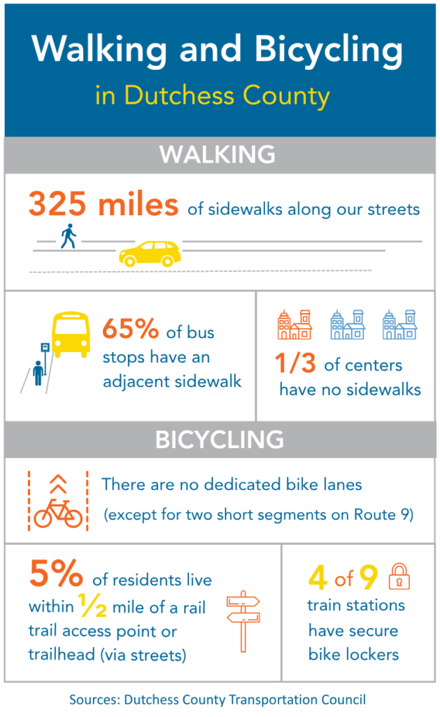
Sidewalks are most useful when they connect nearby destinations—the places we go every day. Dutchess County has almost 325 miles of sidewalks along its streets, concentrated in cities, villages, and town centers. However, within these areas, sidewalks are not evenly distributed.
The amount of sidewalk coverage in our 76 centers (as designated by the County Planning Department (.pdf)) varies substantially, and 25 centers (one-third) have no sidewalk coverage at all. Overall, centers in the cities of Beacon and Poughkeepsie, the villages of Wappingers Falls and Rhinebeck, and the Arlington area have 50 percent or more sidewalk coverage, other village centers have 20 to 35 percent sidewalk coverage, and centers in suburban and rural areas have less than 20 percent sidewalk coverage.
Of course, walkability is also influenced by many other factors: whether there are destinations close enough to walk to, the street network, vehicle volumes and speeds, the quality of sidewalks, etc. We focused on sidewalk coverage for this county-level analysis, but we consider other elements in our smaller-scale studies and may be able to include some of them in a future county-wide analysis.
The Barriers to Reliable Access map shows sidewalks relative to centers.
What We Heard
“Even though most destinations require a drive, it would be nice to at least be able to walk once I have arrived at my destination.”
– Moving Dutchess Forward survey
How many of our streets are walkable?
Ideally, most streets in our cities, villages, and town centers should have sidewalks, but cost and limited right of way mean that road owners often don’t provide them. Local policies that require property owners to maintain the sidewalks adjacent to their property often reduce support for building new sidewalks. In rural areas, roads connecting key destinations should have wide shoulders (at least four feet) to provide adequate space for someone walking or bicycling along them, but again, cost and limited right of way are major hurdles.
While we don’t have complete data on all roads, our analysis of County roads (based on Public Works data) found that about 10 percent of County road miles have shoulders of at least four feet. Another 14 percent have shoulders of between two and four feet. This does not include short segments along bridges/culverts and at intersections—several of which have been improved to include wide shoulders.
We have been working with Public Works to improve sidewalks along County roads in villages and centers (see sidebar). And our sidewalk planning initiatives – Local Pedestrian Plans, the Village of Rhinebeck Route 9 Complete Streets Study, the Spackenkill Road Sidewalk Feasibility Study, and the Arlington Main Street Redesign Initiative – offer ways to expand walkability across our communities.
BUILDING CONNECTIONS
For the past decade, we have been working with County Public Works to improve pedestrian infrastructure on County roads. In 2019 and again in 2025, the County Legislature approved Universal Accessibility funding for these improvements.
In 2020, County Public Works progressed the first project: crosswalk and sidewalk improvements on Dutcher Ave (CR 69) in the Village of Pawling, based on a recommendation in our Pawling Pedestrian Plan. A sidewalk project on Innis Ave (CR 75) in the Town of Poughkeepsie was completed in 2023, and one on Maple Ave (CR 62) in Millerton is planned for 2026, based on recommendations in our Millerton Pedestrian Plan. This will be followed by a sidewalk improvement on Jackson St (CR 34) in Fishkill.
Bicycling
How many people have access to a rail trail?
Dutchess County currently has about 50 miles of rail trails, with an additional 19 miles planned: the Northside Line Phase 2 (0.7 miles), the Hudson Highlands Fjord Trail (5.5 miles), and the Beacon-Hopewell Rail Trail (13 miles).
Rail trails provide protected space for walking and bicycling and have proven to be enormously popular. However, only about five percent of the population currently lives within a half mile of a rail trail access point or trailhead (via roads, many of which lack sidewalks). This would double to 10 percent if the three trails noted above were completed, with most of that increase due to the Beacon-Hopewell Rail Trail.
The Multi-Modal Accessibility Analysis (.pdf) completed as part of our Congestion Management Process identified several significant gaps in our rail trail network, including between the City of Beacon and the Dutchess Rail Trail in Hopewell Junction; between the Dutchess and Harlem Valley rail trails; and between the Dutchess Rail Trail in Poughkeepsie and destinations to the north.
Several opportunities have been identified to convert old rail lines to rail trails. In 2025, we completed a feasibility study for the Beacon-Hopewell Rail Trail (see sidebar). Other opportunities include a Hucklebush Rail Trail between Rhinebeck and Millerton and a Stanford-Pine Plains Rail Trail.
BEACON-HOPEWELL RAIL TRAIL
In 2025, we completed a feasibility study of converting a 13-mile section of abandoned rail line between the Beacon train station and Hopewell Junction into a trail. The study determined that a ‘rail to trail’ project would be feasible and had overwhelming public support. The trail would connect the City of Beacon, Village of Fishkill, Town of Fishkill, and Town of East Fishkill to the Dutchess Rail Trail/Maybrook Trailway and larger Empire State Trail system. While significant funding is needed, we are optimistic that local partners, working with the County and State, will find a way to make this trail a reality.
Where are the on-street bicycle facilities?
While Dutchess County has signed bike routes in various locations, there are no on-street facilities that provide dedicated space for bicycling (except for very short stretches on Route 9), and no on-street bicycle facilities are currently planned. This lack of dedicated on-street bicycling space stands as a major impediment to people feeling comfortable bicycling for everyday travel.
Where is there bicycle parking?
Bicycle parking is an important but often overlooked component of a bicycle network. Our Bike Dutchess app shows locations of publicly accessible bike racks (along with bike routes and nearby points of interest). Based on the app, there are clusters of racks in the City and Town of Poughkeepsie, City of Beacon, and villages of Rhinebeck and Red Hook, while other locations have few bike racks. However, this is an incomplete picture, as we don’t have a reliable system for tracking new (or removed) racks.
Where bike parking does exist, it is usually a simple bike rack, which does not provide long-term security or protection from weather. In addition, racks are often poorly designed, located, and/or maintained, which limits their usefulness. Our Bicycle Parking page provides guidance for bicycle parking styles and installations. Limited bicycle parking, as well as parking that is poorly designed, located or maintained makes it difficult for people to bicycle for transportation.
What is the demand for safe walking & bicycling access?
We began counting people walking and bicycling in 2012 as part of the development of Walk Bike Dutchess, our county-wide Pedestrian and Bicycle Plan. Since then, our count program has expanded beyond annual counts done by volunteers to include video-based counts by a contractor, and we have developed an online app to show the data. While the data is still limited, it reveals key trends and needs:
- The extremely high use of our rail trails illustrates the desire for off-street shared-use paths.
- The high proportion of sidewalk bicycling underscores the need for safer streets with dedicated on-street bicycle facilities, such as protected bicycle lanes.
We also know that there is a high demand for quality walking and bicycling facilities based on the popularity of funding programs such as the Transportation Alternatives Program (TAP). Unfortunately, limited funding is a common barrier to improving the walkability and bikeability of our communities.
What We Heard
“I often encounter intersections that are hostile to pedestrians…They don’t offer a clear option for crossing, vehicles enter them at high speeds, I’m afraid a driver will fail to yield, or the road I must cross is simply too wide.” – Moving Dutchess Forward survey
Our Role
Based on this analysis, our role could include the following:
- Encourage Complete Streets policies & projects. Help municipalities develop and implement Complete Streets policies; continue our local pedestrian plans and work with municipalities to implement improvement projects; coordinate with municipalities, NYSDOT, County Public Works, and County Public Transit to improve access to transit; and assist State, County, and local road owners to incorporate walking and bicycling infrastructure into road and bridge projects.
- Support local ADA inventories & transition plans. Encourage municipalities and other partners to develop ADA transition plans and provide technical assistance as needed.
- Continue to improve pedestrian and bicycle counts to document use and demand. Continue to refine our methodology for pedestrian and bicycle counts, work with County Public Works to install automated/permanent counters on rail trails, and develop a method to extrapolate our counts for annual estimates.
- Promote “all ages & abilities” bicycle facilities. Work with roadway owners to plan and construct dedicated bicycle facilities in centers, and encourage additional bicycle parking, including secure longer-term options, at train stations, transit hubs, park & ride lots, and other destinations.
- Encourage municipalities to treat sidewalks as shared public infrastructure, similar to streets. This would mean budgeting for sidewalk maintenance and plowing as well as new sidewalk construction.
COUNTY’S COMPLETE STREETS INITIATIVE
Over ten years ago, we created a Complete Streets Committee with representatives from County departments including Health, Transit, Traffic Safety, Public Works, and Planning. The Committee developed a Complete Streets policy, which applies to projects involving County roads, parks, and buildings, as well as private projects over which the County Public Works has permitting authority. As part of the policy, we developed a Complete Streets checklist. The checklist is intended to help County staff and private applicants consider ways to incorporate complete streets principles, including access for walking, bicycling, and transit, into proposed projects. We coordinate with Planning and County Public Works staff to review these checklists and recommend improvements to the project.